
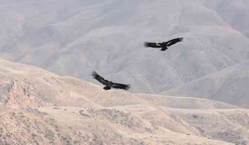
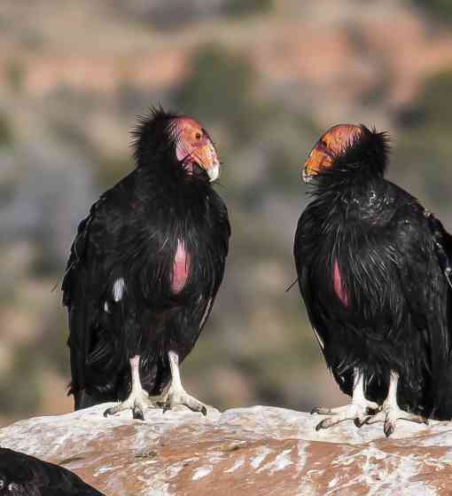
Imagine you’re soaring along, high above the Earth, your nearly 10-foot wingspan (!) essential for staying aloft for hours at a time as you look for food. As a California condor, you know where you live – in the state that bears your name, around the Grand Canyon and up into Utah – but there’s a challenge. The people who help ensure your species’ survival – biologists in the U.S. Fish and Wildlife Service, researchers in universities, members of the interested public – need to know where you live too. In order to do their work, they have to scour different databases, ask people for personal sightings, and find information spread across different sources. Getting all that information together so people can connect the dots, make and agree on a range map, and focus conservation efforts on protecting the proper habitat is essential so you can focus on your next meal.
Conservationists face many complex challenges like understanding where condors live, how to monitor habitat at large scales and much more. The team at the Center for Conservation Innovation (CCI) saw an opportunity to help by bringing many of the tools we need together into a single platform - Conservationist.io, a platform built by conservationists, for conservationists.
At CCI, we work to find creative, pragmatic solutions to daily challenges using science, technology and policy. The monumental problems we are trying to tackle, like the biodiversity crisis and climate change, are made more difficult by the fact that we are often working with limited budgets, and our projects require many different tools, datasets and stakeholders. Bringing these pieces and people together can be a hurdle in and of itself, and finding ways to work more efficiently and effectively can go a long way in achieving the ultimate goal of protecting imperiled species and habitats.
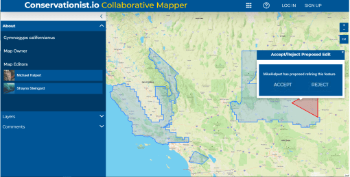
Conservationists.io hosts free public apps designed to help solve important challenges—like the need to know where species actually live, when different range maps are too often inaccurate. Protections need to be applied where the species exists for the protections to do any good. Inaccurate data can also create unnecessary cost and effort when conservation activities are directed to the wrong places. We designed Collaborative Mapper, one of the flagship apps of Conservationist.io, to give people an easy, interactive way to collaborate on developing species range maps. It means people can interactively edit and refine geospatial data without sending files back and forth by email or thumb drives. Not only can Collaborative Mapper help ensure everyone is on the same page in understanding the range for condor conservation, Collaborative Mapper can be used in forest-management planning, reserve design and more…any place we need people to come together to map the places that need to be protected.


Another common bottleneck in conservation work is the substantial cost and effort required to monitor and enforce the thousands of conservation agreements that protect species and habitats. With limited budgets, this often means these agreements go unenforced, and the true status of protected areas remains unknown. We built Habitat Patrol to help conservationists use near real-time satellite imagery to automatically detect land cover changes in areas of interest. Historically, editing geospatial data and monitoring land cover change with satellite imagery would have required multiple different software, large datasets and specialized training and expertise. Now, conservationists with diverse backgrounds can accomplish these tasks in one place without any specialized skills or knowledge. It’s not hard to imagine any number of situations where both analyses would be part of a single project. The U.S. Fish and Wildlife Service regularly checks on the state of imperiled wildlife populations and their threats, including habitat loss. With the tools available on Conservatonist.io, a user can measure the amount of habitat lost within a species’ range, and update that range to reflect that loss, new information or to correct historical inaccuracies.
Conservationist.io is in its beta version – that means that the platform is up-and-running, but open for more testing and early input for development. The next step is to build features that let users combine outputs from different tools into a single analysis or report. This is the real power of the platform – interoperable tools in one place. We have also begun development on two new apps that will also address recurring needs in conservation project workflows. You can help us grow and improve Conservationist.io by signing up as a user and participating in different beta testing activities. Your feedback will help ensure Conservationist.io continues to be built by and for conservationists. In doing so, you’ll be helping to ensure that condors can fly free while those of us on the ground work together to protect the habitats that need to be protected.
Author
comments
Wildlife & Wild Places


