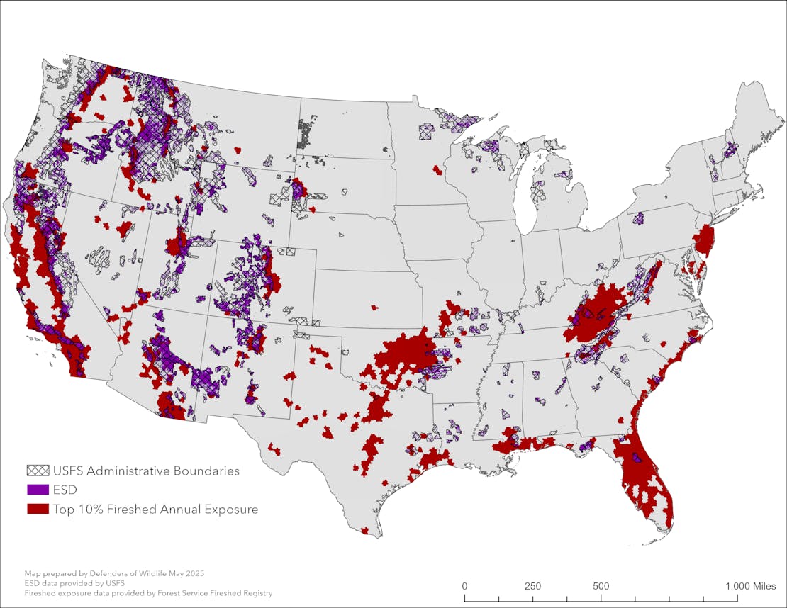
Firesheds with the highest ranks for community exposure in relationship to the Emergency Situation Declaration Area.
In the early months of the second Trump administration, “emergency” orders have become a seemingly routine tool employed to tell agencies to fast-track resource extraction on public lands and skip past crucial requirements of our environmental laws.
In March 2025, President Trump issued an Executive Order entitled Immediate Expansion of American Timber Production. Citing “heavy-handed Federal policies” that have prevented logging, the order calls for increasing timber production on our national lands and “streamlining” environmental permitting. This includes bypassing measures designed to prevent jeopardizing threatened and endangered species.
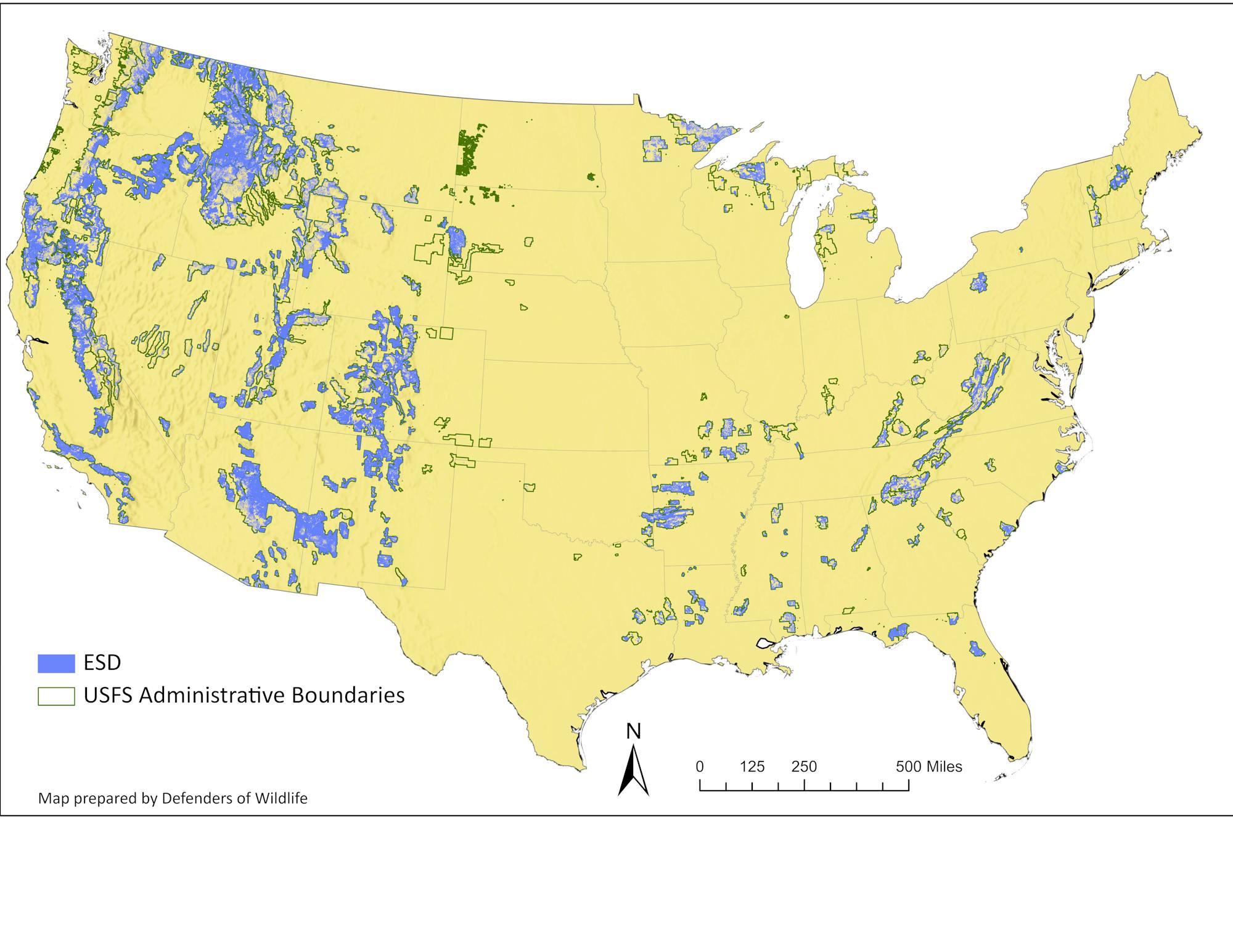
Secretary of Agriculture Brooke Rollins, who oversees the U.S. Forest Service, subsequently issued a secretarial memo to launch implementation of Trump’s executive order, declaring an “emergency situation” across our national forests. She established an Emergency Situation Determination (ESD) area in which the Forest Service can fast-track logging by shortcutting environmental safeguards, public participation and legal review.
The ESD area is substantial, encompassing 113 million acres1 or almost 60% of our national forest lands. An area bigger than the entire state of California!
To add to the farcicality of the ESD, the directive allows for any project with at least 50% of its acreage within the ESD to operate under the fast-tracking provisions. This expands the reach of the ESD to even more of the national forest system.
While we cannot yet know where and how fast the Forest Service will log within the ESD area, we can take a closer look at the places implicated by this sweeping declaration. Defenders of Wildlife created an interactive map viewer to show how the administration’s ESD could affect wildlife and native habitats.
What we found is that the ESD area overlaps with more than:
- 20 million acres of designated critical habitat for threatened and endangered species under the ESA.
- 8.4 million acres of areas identified necessary for grizzly bear recovery, which represents about one-third of all grizzly bear recovery zones in the United States.
- 26 million acres of Inventoried Roadless Areas. This is about 44% of all inventoried roadless areas, larger tracts of relatively unfragmented habitats crucial for wildlife.
- 11 million acres of designated Wilderness Areas, places protected by Congress as natural areas and where development and resource extraction are disallowed. This is about one-third of all Wilderness in the National Forest System.
- 340,000 acres of Research Natural Areas, places set aside to provide ecological information, maintain biological diversity, and promote research and education. This represents about 70% of the Forest Service RNA network.
In fact, one-third of the ESD is Inventoried Roadless Areas or Wilderness Areas, places that are conserved to protect large unroaded areas that can provide quality core and connectivity habitat for wildlife.
Designated conservation areas should be off-limits to industrial logging and roading and excluded from the ESD and its fast-tracked proposals designed to log first and ask questions later.
“Emergency” Area Designation Not the Solution to Safeguarding Communities
Since the ESD on its face is about addressing emergencies, we took a look at the data to see how well the ESD might target places in national forests that, if they were to catch fire, would pose the highest threat to buildings and communities (“very high exposure firesheds”).2
Firesheds are 250,000-acre blocks mapped across multiple jurisdictions that share fire behavior.3 We ranked the firesheds that overlap the National Forest System to identify those in the top 10% for fire exposure and found that 65% of these are captured by the ESD. However, because the ESD is so large, these account for only 12%. Thus, while over half of the very high exposure firesheds are included in the ESD, they are a small fraction of this larger “emergency” area.4
As the map shows, the majority of the highest exposure firesheds lie outside of the National Forest System.
Bottom Line
The bottom line is that the administration’s timber “emergency” blankets most of the National Forest System, opening it to expedited logging and other land management activities. The ESD captures – and threatens –millions of acres of conservation areas crucial to wildlife while likely failing to focus where the fire exposure is highest.


1 The Secretary’s memo states that the ESD is 113 million acres. We mapped the ESD using Forest Service coverages and found it be closer to 111 million acres. We used our figure in our calculations.
2 Targeting high exposure firesheds for fuels reduction through prescribed burning and thinning is a central component of the Forest Service’s 2022 Wildfire Crisis Strategy. See Confronting the Wildfire Crisis - A Strategy for Protecting Communities and Improving Resilience in America’s Forests, page 4. FS-1187a. January 2022.
3 https://research.fs.usda.gov/sites/default/files/2023-03/rmrs-firesheds-ataglance_april2022_0.pdf
https://research.fs.usda.gov/rmrs/projects/firesheds
Author


